New Year's Resurrection
The resurrection came and went without much fanfare. It was nearly a decade since the last of the annual hikes up to "God's country" slipped into infamy. During that time only bad memories of a doomed hike came to mind. But all that changed in 2005.
Incredibly, since August 2005 a new party of hikers helped lay the foundation for its revival. They turned the annual event into a bi-monthly and sometimes weekly trip through the natural. Comprised of old and new faces the group would contribute to the expansion of our repetoire of hiking trails.
On this revival trek, only two of the original group returned. Of the six members, four were either out of state, out of breath, or out of mind. It would be just me and my eldest bro accompanied by a few of the new crew. Given the personal obligations during the holiday season we expected a low turnout. We knew it would at least be a two-man hike just as it was when we first regrouped in the summer.
Back in late August, my bro & I hooked up in late summer to test the waters. It went down a week after my return trip up the mountain. On that first hike I regained the passion that was lost nearly a decade before thanks to the motivation of my hiking bud.
The reunion hike continued to be a motivating tool as it pushed physical and mental endurance to higher limits. With the falls as the goal we hoped to find a fitness gauge to target for the yearend hike. And now, with greater endurance and experience it was game time. Our goal, the source pool that fed all waterfalls in that mountain range.
Why there isn't much information about source pools is sad. Perhaps, the pool itself is shrouded in clouds or a large canopy of trees hides it from aerial view. Whatever the case one (or more) must exist and it was our hope to find it!
Knowing what lay ahead the emphasis was on planning and preparation. It would be a long, possibly wet hike which meant food, extra water, extra socks, jacket/poncho, and durable footwear. The choice of general clothing was left to the disgression of each hiker.
With prior experience from this type of hike we decided to lead/close the ranks of the expedition past the closed trail. Extra water, extra food, and several hundred feet of rope was also left to our burden. Fortunately, most of the additional weight was either edible or expendable.
Getting back to game day, it came quick and started late. There were some last minute cancellations that threw off the schedule. The disarray soon turned to order as we got our act together and arrived at the trailhead. What could have been a sign of bad karma became overshadowed by excellent hiking conditions.
By the time we hit the trail it was mid morning but the dry trail made up for any lost time. With blue skies smiling down on us and a nice breeze for comfort we blazed through the trail. The action was so fast that we arrived at the lookout in less than an hour.
There was some screwing around along the way such as in the bamboo forest. A group of hikers who seemed to have lost their way at one of the trail junctions were obviously entertained by our choice of hiking apparel. Smiles were exchanged as we passed but as expected a comment about the necessity for a heavy gauged rope was made. I followed it with my own comment that basically equivocated STFU.
For a brief time we waited at the next junction hoping they wouldn't follow us but they did. We hid for a bit until they passed but they were already headed in the direction we were going. The lookout.
When we got there the kids immediately headed up the hill to the mudslide. Strange noises could be heard and as I approached it became apparent they were trying to lure the other group up to this trail while we slipped unseen to the other one. Though the attempt failed we eventually proceeded onward following a few minutes of curious stares and terrible stories of hiking greatness by people using inaccurate descriptions of trails they purported to have been.
We rushed past them in an effort to lose the tag-a-longs. I retook the lead out of familiarity and rushed up the hill to increase the distance. As the party caught up we watched as the group of hikers attempted to follow us. After a quick chuckle we picked up the pace and continued on.
I tried to maintain a 20' gap from the rest of the party. Since we had more inexperienced hikers it made more sense to scan for obvious trail hazards up ahead rather than get caught by surprise. A fresh reminder was the tragedy from a weeks prior that kept us cautious of the surroundings and each other. In retrospect, as is always the case we have been blessed with safe hikes.
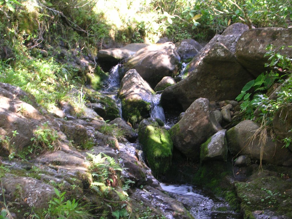
Continuing upward, we finally reached the area where the first waterfall becomes visible. Despite dry conditions the water still ran fairly free and heavy. The unmistakable sound of running water could be clearly heard hundreds of feet across the vast drop off.
We pushed on until the clearing to the waterfall's trailhead was visible. Like the others it snakes downward along the spine cutting through earth and rock until reaching the stream bed. Though a few of those are regularly marked by surveyance tags they are not at close intervals and wrong turns are inevitable.
Knowing the source pool would be much higher we headed up to the next spine. The climb was quite taxing and compounded by the extra weight of the ropes and additional food & water. It was worse for the others since this was their first trip this far up. As I reached the top and waited for the party to catch up I decided the trek might go bad if we pushed too far. After some discussion, the decision was made to descend on the lower fall instead.
Returning to the lower waterfall trailhead we headed down. Although dangerously steep in areas, the path was clear and manageable due to the dry conditions. To avoid unnecessary injury, we placed rope guides at long drops for assistance on the climb down and back up. The distance down is several hundred feet so the ropes were secured at strategic points.
There was more water than anticipated as the stream ran swiftly down hill. Though refreshingly cold and crystal clear it was far from drinkable. Even running water can contain enough bacteria to cause severe illness. As a general rule of thumb, always pack more water than you need as long as the total weight is negligible over the course of the hike. We packed sufficiently and thought of replenishing our supply only in necessity of life and at our own health risk.
Sighting some familiar looking landmarks we cruised downstream along the rocks and bushes. The debris from previous landslides and flashfloods had caused much of the path to dam up. In some areas it was odd to see water streaming out of a large rock but that's what happens with water. It pushes and prods until it finally gets through the obstacle.
For the first hour or two, we assumed this was the same path we came down last summer. Yet even with some familiarity most of the area felt all too foreign. Could it have been a more recent flashflood that recarved the bed and walls? The answer lay up ahead.
Funny thing about the trek downstream is that it required the utmost caution and balance to avoid getting wet. There's so much twists and turns under and over obstacles that one precariously placed step could get you soaked. Not so funny, is that it happened more often than we would have liked.
Here's a good one. We came to a small waterfall ledge with a height of about three feet or so. The only way down was to either walk up the side of a steep, slippery hill side and probably end up falling or simply pass over some boulders. Sounds easy but it was a stupid trick.
The boulders almost form a wall with shallow, partially hidden footholds. Because you can't see below until you've already committed to step chances are you'll hit water. In addition, the area is small so there's isn't much momentum to be gained for a jump. So a five foot jump from one side of the boulder to the other either meant dog shit or splash!
Someone got wise to it and dragged a large broken branch to use as bridge. The bridge idea works great in theory but only if both ends are firmly braced. It is very unforunate for the first guy who figures that out and the last guy who no one gives a shit about and leaves him to his watery fate! Yeah, me!!!
Anyway, there was a bunch more comedy including some cool matrix wall running moves and pile ups, stupid pole vaulting tricks, and endless slips into the water. You'd think it was full of crap the way everyone fought to keep themselves from the slightest plunge. It's actually a good thing to keep dry but we kinda took it too literal.
After a short lunch break we pressed on heading downstream. There was more slipping and lots of pix. In time, the end of the road came into view.
The water starts flowing heavily from about 50' to the end. You can hear crashing sounds similar to that of white water rapids. Here, the water runs so quickly that if you slipped and fell in you'd be pulled downstream along the slippery bed of rocks.
In this area, especially 20' or so down the walls narrow into a semi smooth surface seemingly cut by the flowing water. There's a three to five foot drop into a death trough where the immediate walls rise over 50'. The trough ends abruptly in a cliff where nothing but open sky is visible. So, if you were unlucky enough to be swept into this area or dumb enough to jump in here, it'd be the end of the line for you.
From our safe position, we really couldn't confirm the finality and for a moment entertained the idea of someone venturing into the trough (with a rope harness!) to verify it. Sounded like a plan to me but someone found a side trail just to the right of the drop. It took us up about 15' or so through a marshy path that ran like a stream. We were sort of amazed considering the path went uphill and the water still flowed with enough force over the edge.
We were now at an excellent vantage point of verification - the stream ended in a sheer cliff. The interesting thing is that it turns out the waterfall is the same one that is visible from the main trail. From this side a lot of things came into perspective.
It wasn't obvious until that point just how dangerous the trail really was. We had assumed for years that a fall could be recovered since it would be at a constant grade. But the view from the waterfall shows only a 30' grade followed by over a hundred foot sheer drop.
There was some good time spent here before we finally headed back upstream. At this point, we were starting to tire but had to get back onto the ridge by late afternoon. The pace was pushed to asure this but not without some pain.
Before starting the climb up the ropes we figured we had some time to at least check what was further upstream. In no time, we reached the end but this turned out to be a surprise. We found ourselves (my bro & I) back at the same waterfall we started on almost 20 years ago! It was like deja vu.
Even more nuts was the fact that this waterfall was the same one that we had to turn back on last time (see Waterfall Revisited). It was like tying up loose ends. Although we didn't find the source pool, we were able to connect the dots on the last fall all the way up to where we started last time.
Well, before more sentimentality and laziness started to set in we headed back to the ropes. The ropes made it way easy to climb out. We left some on the trail for other hikers to use as well as they are always great help.
Took us a long ass time to get out that day. The trip was over 10 hours but well worth it. By the time we got home, the holiday festivities were rolling. I was beat and hungry, but with renewed hunger in completing the final leg of that hike and blasting through new challenges!


posted by skunkratt @ 9:48 PM
0 comments
![]()

0 Comments:
Post a Comment
<< Home